Saturday, February 10, 2007

Water Extractions: Moree

More images from Google Earth, these ones showing the cotton plantations around the town of Moree. The Gwydir River which flows to the Barwon and then the Darling runs thru the town. These lazer graded areas are NW of the town, taking water from a tributary of the Gwydir. As you can see from this first image - some parts of GE have more detail than other sections. The 'ring tanks' are the white and blue square/rectangular areas.


Zooming a little closer and the waterway wiggles diagonally thru the centre. Unlike farming country there are no trees on cotton plantations. The land is lazer graded with a gradual slope for water to reticulate down the rows of cotton bushes. Each bay is divided not by fences but by open chanels of water.


You can gain some sense of scale from the trees to the right of the image - those ring tanks are big! Because animals do not graze the harvested cotton bushes there is no need for trees or fences (to shelter and contain the animals). When I visited Bourke in 2002 the dead cotton bushes were raked into large piles with huge machines and set alight. A very dramatic image but environmentally hazardous.


A close up showing the huge amount of earth moving, chanelling and flattening of the landscape. The banks around the ringtank and alonside the chanels are also roadways for cars and trucks.

The wooded area to the right gives an indication of the trees removed by the cotton operation.


Diesel is required for the pumps which are under the metal structures on the chanels. The trees are the large Red River Gums and give some indication of scale.
In the image below werve zoomed out again, showing the area just looked at - and the area beyond it. Wherever there is a waterway the land is also divided into cotton plantations with the blue area indicating the water storage 'ring tank'. The town of Moree is just above the Google logo.


Water Extractions: Wee Waa

More from Google Earth! These images show that although Cubby station just over the border in Qld takes a lot of water - there are many smaller places taking water across northern NSW. The town of Wee Waa on the Namoi, south of Moree is surrounded by cotton plantations. in this image the town is in bottom right corner. If you double click it jumps to screen size.


Two images below are details of the top image. As the resolution of GE is not as good here the square ringtanks show as blue and fields are either green or brown.


This shows the area North East of Wee Waa. again acres of cotton plantations and ringtanks.

Detail (below) showing open water chanels and ring tanks. For a sense of scale this image is 19.5 klms across - a huge area with no native vegetation, trees or bushes left to stabilise the soil. Welcome to 'the country' in the early 21st century.


Inland Sea at Wagga Wagga

Ive just made a big discovery!! Maybe you know this already ... but, if you double click on the images - they enlarge to screen size. It is particularly effective for the stereo images in previous posts.


These are images from my current exhibition at the Wagga Wagga Art Gallery down on the beautiful Murrumbigee River. Ive been making aerial photographs of the patterns made by native vegetation out on the Darling. So ... Ive been flying large kites with cameras attached. Yes ... its a good excuse to run about in the beautiful landscape out there! Out in this open grazing country - no checkerboard of ploughed fields out here - topography, water and wind create beautiful organic shapes and colours. Cutting through these patterns are the straight lines (yes humans are fairly blunt creatures) of fences and roadways and the electric grid. These two patterns, the organic and the linear, appear to have little relationship to each other.


This work is called Inland Sea and is a map-like pattern of the names of creeks and rivers which flow into the Darling. As i was pouring over maps i noticed that many have Aboriginal names and here, is an Aboriginal and colonialist history written into the landscape. The work suggests the flow of sustaining floodwaters across this vast semi-arid country. Baaka is the Bakindji word for the Darling.
In times when Queeensland rains come down the Cuttaburra channels and the Paroo, Warrego and Culgoa to the Darling a vast, expanse of water covers the country for miles in all directions. The explorer Charles Sturt fantasised about water of this dimension. An ardent ortholigist, he watched waterbirds setting off from Adelaide to the inland. He became obsessed with searching for these vast and unpredictable inland seas and continued to search the deserts of SA into his old age. (the link is to Sturts publication 'two expeditions into the interior of south australia')


Monday, February 5, 2007

Comparisons 1: Less and less

I travelled out to the Darling River for x-mas again this year. The river is in an almost waterless state having stopped running two months earlier this year on 8 September 2006. For those new to the tragedy of the Darling, the river has been a chain of waterholes almost every year in the summer months since 2000. So when the temperatures are up in the 40,s and you would like a swim - there aint much to swim in. This has been compounded by the blue- green algae, a poison which causes skin to itch on contact. Water infested with algae also smells - a combination of dead fish and dead fox - two of the most repugnant odours around!! Most homesteads and the small towns on the Darling have sunk bores next to this iconic and beautiful river, into the sub-riparian water, in order to run a household.

Darling below Wilcannia, December 2006. not even puddles for birds and kangarooos.
Each year since 2001 the dry summer period has become longer. In 2006 after a long, dry summer, the river began to flow again in March over the cooler months. As it stopping flowing again on 8 September there was in effect only six and a half months of a river in the 2006 year.


Darling Below Wilcannia, January 2003


Up-river around the town of Bourke, in southern Qld and northern NSW, cotton is planted in late spring and watered over the summer months. The water in the river system is pumped into huge 'ring tanks', like large paddocks for water storage, ready for the hot growing season required by cotton. Over summer it is also fertililsed and sprayed with insecticides. While the ring tanks are full of water - the river looks like it does in these photos.


Darling River below Wilcannia in October 2002. Still some puddles of water in October.


Two ringtanks on the Barwon River near Mungindi on the Qld NSW border.

This is cotton irrigation courtesy of Google Earth. Notice the wier in the bottom centre of the image. Water is pumped from above the wier and stored in the ringtanks (the two white-ish areas) - leaving the river downstream extremely depleted . Google Earth can reveal lots of whats going on in what you may have thought was farmland with rolling hills and cute furry animals. Welcome to large scale irrigation with lazer graded, treeless plantations. For a sense of scale, the image is 1.7ks across. Large river gums can be seen along the river course.

Monday, January 1, 2007

Underwater fencelines

One of the effects of the river going dry is that there is no longer a boundary fence. Like anyone, sheep love to explore new territory!! You either destock the river paddocks - or have a floating population of neighbours sheep mixing with your own. When the river comes down again - you muster and truck them back again - expensive and time consuming. What my brother has done is to build temporary fences down the middle of the riverbed, filling up the gaps between the waterholes. This is obviously also time consuming. A fence in the bottom of a river bed is a visual conundrum. Here are some images of the process;


The fences are made from blue binder-twine with bamboo, gum and box tree 'posts'.


One of the negative aspects of sharing photos of the waterless Darling is that they could serve to 'normalise' our expectations for a river, and hence our practice of using the water for short term economic gains. With environmental and longer term concepts in mind - it is obviously the river that requires water for the continued survival of the river chanel itself and the billabongs and floodplains beside it.
Here are words from Thomas Mitchell describing the (fairly low) Darling River in 1835. The river he saw, called Baaka by the Bakindji people, was managed entirely with Aboriginal world views and attitudes to water use;
July 2nd: "The river and its vicinity presented much the same appearance here that they did 200 miles higher up. Similar lofty banks ... with marks of great floods traced in parallel lines on the clayey sides; ....transparent water, with acquaticplants - a slow current, with an equal volume of water - fine gum trees and an abundance of luxurious grasses."
August 4th: "We, during a sojourn of more than two months in the Australian wilderness, have been abundantly suplied with the finest water, from that extrordinary river which we had been tracing, and without which those regions would be deserts."

Friday, December 29, 2006

stretches of dry river bed


just returned from xmas visit to my family who live on the Darling ... sadly a chain of waterholes for miles both above and below Wilcannia. In between the waterholes are long stretches of completely dry river bed. It seems to be the driest ever seen on this Darling section of the Murray Darling Basin. This is a view of the river from the bridge at Wilcannia - a turgid, sad, green mess.


And another one showing the stretches of dry river bed - in between the waterholes.


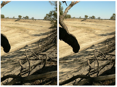
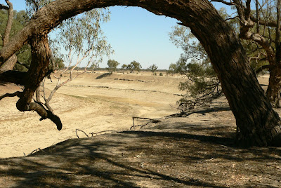
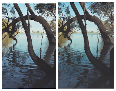
Following are some comparison photos; Again more of my Stereo images (see previous posts on 'free viewing'). This one shows the totaly dry river bed - in a bend i have photographed since 1991 when we first saw the river a thin trickle of barely flowing water. Compare it to the last flood of 1998 to 2000, taken from a similar place .


Archway, December, 2006


Archway, December 2006


Archway, 1998 Flood

There is some good news - not all gloom n doom. The water quality is on the improve. With very little cotton being produced there are less insecticides, pesticides and fertilisers going into the river and the water is for the first time in ages pretty clear with beneficial river weed for fish and water. So far this season no outbreaks of hyperfertilised Blue-green algae.

Monday, December 4, 2006

Darling in flood. 1998


This stereo image and the one in previous post are taken from the same place (this one further back among trees as water was too deep where i had stood two years previously!). For this image i travelled up river in small dingy as the usual roads were covered with floodwater. It is fairly formidable - and such a buzz - when the water has reached the top of its banks and flows over the flat expanse of country on either side. There is an amazing volume of water and a view thru the trees into the surrounding country.


Scroll down for info on how to free view this image in Stereo!

For various reasons, mainly the huge extraction of water upstream from the Darling, 1998 to 1990 is the last time the Darling has seen such a flood